Laser Measurement Tool
The Laser Measurement Tool [LMT] is a very simple tool to measure distances up to 100m for solid walls and 40m to power lines or soft targets such as vegetation.
Once mounted in a scenario, indoor or outdoor, it measures 2D profiles in a matter of seconds.
The main sensor is a 360º laser scanner designed for obstacle detection; it can perform up to 5 full-circle scans per second. Each circular scan has a maximum of 1440 samples. The accuracy is better than 2cm for solid targets across all range.
Without loss of simplicity, the system has been designed with a number of convenient features:
- It's weather proof and can be operated under rain.
- It's portable: all materials can be carried inside a weather proof case that also acts as a power controller.
- There is a wireless Wi-Fi connection that allows the operator to sit comfortably at a distance (hopefully, safe from the rain) and operate the system.
- There is an optional GPS receiver so that every profile taken outdoors can be tagged with its localisation and time of scan.
- It exports data into popular CAD formats DWG, DXF or CSV.
The LMT can be used for:
- 2D profiling
- Floorplan creation
- Virtual heritage
- Ground maintenance inspection
The software is easy and intuitive to use and allows the data analysis on site or the data exportation for detailed analysis on a CAD software.
This product can be purchased or rented. Albatroz Engineering is also available to offer the measurements as a service. For further information, please contact us.
There are two LMT brochures, one related to power line inspections and the other related to construction measurements.
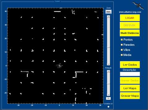
User Interface at an underground parking lot
 LMT mounted on a tripod
| Technical specifications
|
|
| Range | 40 m @ 20% reflectance |
| 100m @ 80% reflectance | |
| Error | < 2cm (all range) |
| Angular resolution |
0,125 |
| Autonomy | > 350 imagens/profile |
| Dimensões (c/ mala) | 330x234x152 mm |
| Mass (w/case) | 7Kg |
 LMT in its protecting case
| LMT Content
|
| Sensor laser |
| Wireless communication modules |
| Battery 12V-5Ah e charger 230V |
| Cables and control box |
| Tripod de 2,3 meters / 4Kg |
| Carrying case |
|
CD with software and manual |
2D Profiling
This solution is aimed to professionals of civil engineering, architecture or topography that need a precise and quick system to measure distances for different type of applications:
- Comparison between projected work and executed work,
- Floor plan update for reconstruction work,
- Roads and tunnels profiling,
- Any type of 2D profiling.
The software is easy and intuitive to use and allows the data analysis on site or the data exportation for detailed analysis on a CAD software.
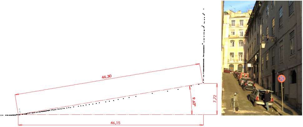
Street inclination (or slope) measurements in Lisbon, Portugal


Triumph Arch at Praça do Comércio*, Lisboa, Portugal
*also known as Terreiro do Paço
Vertical and horizontal section at the height of 1.5m above the ground level